Summary
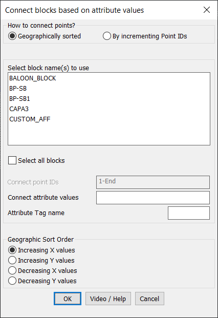
The CP_CONNECTBLOCKS command in CADPower allows users to connect blocks in a drawing by creating polylines based on their attribute values. This tool is highly efficient for automating the connection of blocks, saving time in organizing and managing block relationships in CAD workflows.
CADPower -> Blocks Tools -> Block – Related -> Connect blocks based on attribute values

Key features include:
- Block Connection Methods:
- Geographically Sorted: Connect blocks based on their geographic arrangement in the drawing.
- Sort by Increasing X Values: Connect blocks in ascending order of their X-coordinates.
- Sort by Increasing Y Values: Connect blocks in ascending order of their Y-coordinates.
- Sort by Decreasing X Values: Connect blocks in descending order of their X-coordinates.
- Sort by Decreasing Y Values: Connect blocks in descending order of their Y-coordinates.
- By Incrementing Point IDs: Connect blocks based on the numerical order of their point IDs as specified by their attribute values.
- Geographically Sorted: Connect blocks based on their geographic arrangement in the drawing.
- Flexible Block Selection:
- Choose specific block names to use for connections or select all blocks in the drawing.
- Filter blocks by their attribute tag name to ensure only blocks with matching criteria are connected.
- Customizable Point ID Range:
- Specify a range of point IDs for the connection using flexible syntax:
- Example:
1-50,60,90-Endconnects blocks with point IDs from 1 to 50, then 60, followed by 90 to the last block in the drawing.
- Example:
- Use
StartandEndas special values to refer to the minimum and maximum point numbers in the drawing.
- Specify a range of point IDs for the connection using flexible syntax:
- Output as Polylines:
- All selected blocks meeting the specified criteria are joined by a single continuous polyline, ensuring a neat and logical connection between blocks.
- User-Friendly Interface:
- Intuitive dialog box for setting block selection, attribute tags, and connection criteria.
- Integrated help and video tutorials for easy understanding and quick onboarding.
- Applications:
- Useful in GIS, surveying, and engineering workflows to connect data points, nodes, or blocks based on attributes.
- Automates the process of creating paths or networks based on spatial or attribute relationships.
- Enhances productivity by eliminating the need for manual connections.


Use Case:
The CP_CONNECTBLOCKS command is ideal for professionals in surveying, mapping, and civil engineering. It simplifies the process of organizing and connecting blocks in a systematic way based on geographic or attribute criteria.