Summary
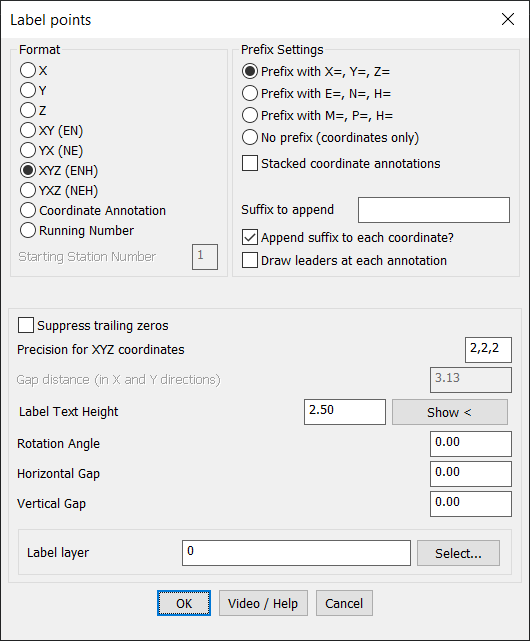
The CP_IDXYZ command in CADPower is designed to label selected points in a drawing with their coordinate values in a variety of formats. This tool provides extensive formatting options, making it ideal for annotating points with precise location data in both 2D and 3D.
CADPower -> Annotation Tools -> Annotation Tools -> Label points

Key features include:
- Coordinate Label Formats:
- Label points with various coordinate representations:
- X: Displays only the X-coordinate.
- Y: Displays only the Y-coordinate.
- Z: Displays only the Z-coordinate.
- XY (EN): Displays X and Y as “E=, N=”.
- XY (NE): Displays X and Y as “N=, E=”.
- XYZ (ENH): Displays X, Y, and Z in “E=, N=, H=” format.
- XYZ (NEH): Displays X, Y, and Z in “N=, E=, H=” format.
- Coordinate Annotation: Customize coordinate labels for specific use cases.
- Running Number: Add sequential numbering to points.
- Label points with various coordinate representations:
- Prefix Settings:
- Choose from predefined prefixes (e.g., X=, Y=, Z= or E=, N=, H=) or opt for no prefix for raw coordinate values.
- Enable stacked annotations for compact labeling.
- Append a custom suffix to coordinate labels for enhanced annotation.
- Annotation Customization:
- Set precision for X, Y, and Z values separately (e.g., 2 decimal places for each).
- Option to suppress trailing zeros for cleaner annotations.
- Add leaders to connect annotations to their respective points for clarity.
- Layout and Spacing:
- Adjust Text Height, Rotation Angle, and Horizontal/Vertical Gap for annotations to ensure readability.
- Specify the layer for labels to keep your drawing organized.
- User-Friendly and Efficient:
- Intuitive dialog box with real-time formatting options.
- Integrated video and help resources for quick assistance.
- Applications:
- Ideal for land surveying, GIS mapping, construction layouts, and any scenario requiring labeled coordinates.
Use Case:
The CP_IDXYZ command is essential for CAD users who need to annotate point coordinates accurately and flexibly, whether for technical documentation, fieldwork preparation, or spatial analysis. Its range of options makes it adaptable to diverse workflows and standards.