Summary
The CP_SEGLABEL command in CADPower allows users to annotate segments of polylines, splines, arcs, and lines with detailed labels. This versatile tool provides extensive formatting options, making it ideal for projects requiring segment-specific annotations such as distances, bearings, slopes, and more.
CADPower -> Annotation Tools -> Annotation Tools -> Label polyline segments

Key features include:
- Annotation Options:
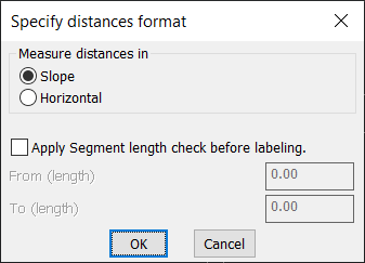
- Distances: Annotate inter-vertex distances.
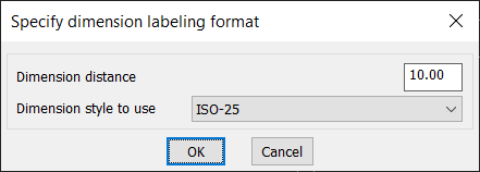
- Dimensions: Display dimensions along the segments.
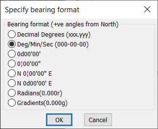
- Bearing: Add surveyor’s bearings between two vertices.
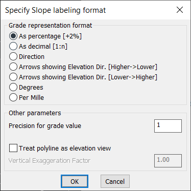
- Slope: Annotate segment slopes with customizable formats.
- Distances@Bearing: Combine distance and bearing into a single annotation (e.g., “100m @ N30°E”).
- Distances@Slope: Combine distance and slope into a single annotation (e.g., “5m @ 10%”).
- Running Numbers: Number segments sequentially.
- Running (Incrementing) Characters: Use characters for sequential labeling (e.g., A, B, C).
- Cumulative Distances: Calculate and annotate cumulative slope or horizontal distances from the start.
- Label Formatting:
- Customize label formats for distances, dimensions, bearings, and slopes.
- Bearing Formats:
- Decimal Degrees, Degrees-Minutes-Seconds, Surveyor’s Units (e.g., N 45°E), or Radians.
- Slope Formats:
- Percentage (e.g., “10% Up”), Decimal Ratios (e.g., “1:20 Down”), Directional Arrows, Degrees, or Per Mille.
- Precision Control: Set the number of decimal places for distances, bearings, or slopes.
- Annotation Placement:
- Along Segment: Place labels along the segment’s direction.
- Perpendicular to Segment: Position annotations perpendicular to the segment.
- Additional Placement Options:
- Above/Below/On Segment: Customize placement relative to the segment.
- Left/Right of Segment: Adjust placement for perpendicular annotations.
- Text Orientation:
- Always Upright: Flip text to ensure readability.
- Always Aligned: Keep text aligned with the segment direction without flipping.
- ARC Label Options:
- Midpoint of Arc: Place labels at the midpoint of the arc.
- Midpoint of Chord: Place labels at the midpoint of the chord for arc segments.
- Customizable Parameters:
- Label Text Height: Adjust text size for readability.
- Precision for Distances: Set precision for coordinate values or distances.
- Starting Segment Number/Character: Define initial values for sequential numbering or characters.
- Vertical/Horizontal Text Offset: Control the label’s position relative to the segment.
- Advanced Settings:
- Apply Segment Length Check: Label only segments within a specified length range.
- Treat Polyline as Elevation View: Annotate slopes for elevation views, with customizable vertical exaggeration factors.
- Layer Management:
- Assign labels to a specific layer for better organization and control.
- Interactive Interface:
- Simple dialog box for real-time configuration.
- Integrated help and video tutorials for ease of use.
The CP_SEGLABEL command is perfect for CAD users in surveying, engineering, construction, and GIS. It provides accurate and customizable annotations for linework, helping with documentation, analysis, and field preparation.