Summary
The GT_CH3D2D command in GeoTools efficiently converts selected 3D polylines and lines into 2D polylines and lines, ensuring smooth processing and compatibility within BricsCAD, AutoCAD, ZWCAD and ARES Commander.
GeoTool -> Polyline Tools -> Join/Change -> 3D-to-2D
3D to 2D: GT_CH3D2D – GeoTools Command
Key Features Include:
- Seamless Conversion – Transforms all selected 3D polylines and lines into 2D polylines based on the PLINETYPE setting.
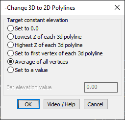
- Elevation Control – Define how the resulting 2D polylines should acquire their elevation.
- Multiple Elevation Options:
- Set to 0.0 – Flattens all polylines to zero elevation.
- Lowest Z of each 3D polyline – Uses the minimum Z value.
- Highest Z of each 3D polyline – Uses the maximum Z value.
- Set to first vertex of each 3D polyline – Assigns elevation from the first vertex.
- Average of all vertices – Calculates an average Z elevation for each polyline.
- Set to a specific value – Allows manual input of an elevation.
Technical Information:
- The GT_CH3D2D command modifies the DXF Group Code 70, removing the 8-bit flag to redefine the object as a 2D polyline.
- The newly created 2D polylines inherit extended entity data (XData) from the original 3D polylines.
Benefits:
This tool is ideal for CAD professionals working in topographical mapping, GIS applications, and civil engineering, where 2D polylines are required for accurate drafting and data processing.