Summary
The GT_AUTOPAN command in GeoTools enables users to draw 2D or 3D polylines with an automatic edge-panning feature, allowing smooth navigation beyond the current screen view in BricsCAD, AutoCAD, ZWCAD and ARES Commander.
GeoTool -> Polyline Tools -> Create/Edit -> Draw 2d/3d polylines with auto-edge panning
Key Features Include:
- Auto-Pan for Continuous Drawing:
- Automatically scrolls the view when the cursor approaches the screen edge, making it ideal for heads-up digitizing and large-scale polyline creation.
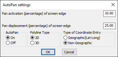
- Customizable Panning Settings:
- Pan Activation Threshold – Defines the screen edge width (percentage) where auto-pan should trigger.
- Pan Displacement – Sets how far (percentage of screen width) the view should shift when panning.
- Polyline Type Selection:
- Choose to create 2D polylines or 3D polylines based on project requirements.
- Coordinate Entry Modes:
- Geographic (Lat-Long) – Uses latitude, longitude, and height-based input.
- Non-Geographic – Standard coordinate system for general CAD drawings.
- On/Off Toggle for AutoPan:
- Enable or disable the auto-pan feature as per user preference.
Benefits:
This tool is especially useful for cartographers, GIS professionals, and CAD users working on large maps, site plans, and complex polylines that extend beyond the current display.