Summary
The GT_3DF2PL command in GeoTools creates 3D polylines from the vertices of selected 3D face objects, enabling better manipulation and editing within BricsCAD, AutoCAD, ZWCAD and ARES Commander.
GeoTool -> Conversion Tools -> Conversion Tools -> 3DFaces to polylines
Key Features Include:
- Converts 3D Faces to 3D Polylines:
- Extracts vertex data from 3DFace objects and generates a corresponding 3D polyline.
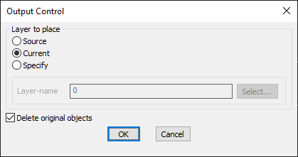
- Layer Placement Options:
- Source Layer – Places the resulting polyline in the same layer as the original 3D face.
- Current Layer – Inserts the new polyline into the active working layer.
- Specify Custom Layer – Allows users to define a target layer for placement.
- Option to Delete Original Objects:
- Users can remove the original 3D face objects after conversion to keep the drawing clean.
Benefits:
This tool ensures seamless conversion of 3D face data into editable polyline formats, improving workflow efficiency in 3D modeling, terrain analysis, and CAD drafting.