Summary
The GT_ENDELEVCHECK command in GeoTools is used to detect line endpoints that share the same XY coordinates but have different Z elevations. It helps identify and manage elevation mismatches in BricsCAD, AutoCAD, ZWCAD and ARES Commander, ensuring accurate 3D modeling and topographical consistency.
GeoTool -> Drawing Cleanup Tools -> Drawing Cleanup Tools -> Check for coincident (XY) endpoints with varying Z spacing
Key Features Include:
- Detects Elevation Mismatches:
- Analyzes lines, polylines, splines, and arcs to find endpoints that are coincident in XY but differ in Z elevation.
- Visualization & Correction Options:
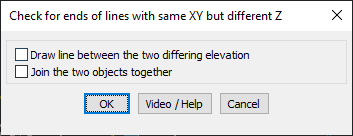
- Draw Line Between Differing Elevations: Creates a vertical line connecting the two mismatched endpoints, helping to visualize elevation differences.
- Join the Two Objects Together: Merges the endpoints into a common Z elevation, resolving inconsistencies.
Benefits:
- Helps in correcting elevation mismatches in 3D linework.
- Improves topographical and terrain model accuracy.
- Enhances survey data integrity by eliminating Z discrepancies.
- Ensures better connectivity in structural and civil engineering drawings.
- Reduces errors in contour and elevation-based designs.
This tool is essential for surveyors, civil engineers, and CAD professionals working with 3D elevation data and terrain models, providing an efficient way to manage elevation discrepancies in linework.