Summary
The GT_ROWMAKER command in GeoTools generates right-of-way (ROW) corridors by offsetting a centerline on both sides by a specified width. This tool is compatible with 2D and 3D polylines, as well as polylines containing arcs and spline objects, making it ideal for roadway design, pedestrian pathways, and transportation planning in BricsCAD, AutoCAD, ZWCAD and ARES Commander.
GeoTool -> Build Tools -> Build Tools -> Make Right of Way/Pavements/Ramps
Key Features Include:
- Create Right-of-Way (ROW) Along a Polyline:
- Offsets the selected road centerline or alignment polyline on both sides to define the ROW boundary.
- Supports Various Polyline Types:
- Works with 2D polylines, 3D polylines, arcs, and splines, making it flexible for different design needs.
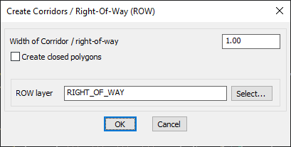
- Customizable ROW Width:
- Users can specify the exact corridor width, ensuring compliance with design standards.
- Layer Management for ROW Elements:
- Allows users to select a target layer (default: “RIGHT_OF_WAY”) where the generated ROW elements will be placed.
- Option to Create Closed Polygons:
- Enables the creation of closed boundary polygons instead of just offset lines, useful for area calculations and visualization.
Benefits:
- Streamlines road and corridor planning by automatically generating ROW boundaries.
- Ensures consistent spacing and alignment in transportation and urban planning projects.
- Works efficiently with topographical and civil engineering drawings, improving infrastructure design workflows.
- Enhances GIS and mapping applications by accurately defining right-of-way extents.
This tool is essential for civil engineers, urban planners, and transportation designers, simplifying the process of creating and managing ROWs in CAD environments.