Summary
The GT_EDGEBUILDER command in GeoTools is designed to automatically generate common edges along adjacent closed polylines (polygons). This tool is particularly useful in GIS data preparation, parcel mapping, and topographical modeling in BricsCAD, AutoCAD, ZWCAD and ARES Commander.
GeoTool -> Build Tools -> Build Tools -> Build common edges along closed, adjacent polygons
Key Features Include:
- Identifies and Creates Common Edges:
- Detects shared boundaries between adjacent closed polylines and generates common edges along them.
- Ensures that adjacent polygons align properly without overlaps or gaps.
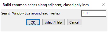
- Search Window for Edge Detection:
- Allows users to define a search tolerance around vertices to ensure edge connectivity.
- Helps in snapping edges precisely, even if slight deviations exist in the polylines.
- Optimized for GIS and Mapping Applications:
- Useful for creating intersection-to-intersection edge networks in topographical maps and land parcel datasets.
- Pre-processing Requirement:
- To achieve optimal accuracy, users are advised to remove duplicate segments using the GT_DISTANGWEED command before running GT_EDGEBUILDER.
Benefits:
- Enhances accuracy and connectivity of closed polygon networks.
- Eliminates gaps and overlaps, ensuring proper GIS topology.
- Automates the manual process of edge alignment, saving time in parcel and zoning mapping.
- Ensures clean data preparation for further network analysis and geospatial modeling.
This tool is essential for surveyors, urban planners, GIS professionals, and civil engineers working with land parcels, zoning boundaries, and infrastructure mapping.