Summary
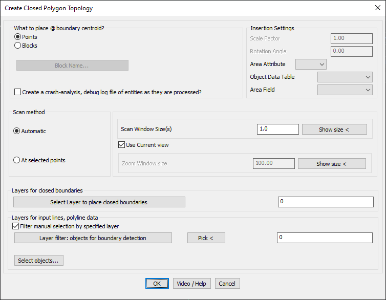
The GT_CCPOLY command in GeoTools is a powerful tool designed to automatically generate closed polylines from a network of interconnected polylines, lines, arcs, and circles. It functions as an automated version of the BPOLY command, systematically applying boundary detection at set intervals to create fully enclosed polygons. This tool is particularly useful for GIS, urban planning, land parcel mapping, and topological analysis in BricsCAD, AutoCAD, ZWCAD and ARES Commander.
GeoTool -> Build Tools -> Build Tools -> Create closed polylines from a mass of networked polylines
Create Closed Polylines From a Mass of Networked Polylines: GT_CCPOLY – GeoTools Command
Create Closed Polylines From a Mass of Networked Polylines: GT_CCPOLY – GeoTools Command
Create Closed Polylines From a Mass of Networked Polylines: GT_CCPOLY – GeoTools Command
Key Features Include:
- Automated Closed Polyline Creation:
- Generates closed polygons from a mass of interconnected lines and curves.
- Uses grid-based scanning to detect and form unique enclosed boundaries.
- Scanning Methods:
- Automatic Mode:
- Scans the drawing at periodic X-Y intervals based on a defined scan window size.
- Suitable for large datasets where boundaries are not predefined.
- At Selected Points:
- Allows users to manually specify points (e.g., known centroid locations) for boundary formation.
- Provides faster processing when scan points are known beforehand.
- Automatic Mode:
- Configurable Scan Window & Zoom Size:
- Scan Window Size: Defines the sampling interval for detecting closed polygons.
- Zoom Window Size: Controls the display area while scanning to ensure accurate boundary detection.
- Layer Management for Closed Polylines & Boundary Edges:
- Users can specify different layers for closed polylines and boundary edges.
- Helps in categorizing and organizing different topological features efficiently.
Benefits:
- Automates polygon generation, eliminating manual boundary tracing.
- Saves time in land-use planning, parcel mapping, and GIS analysis.
- Works with complex datasets, ensuring precise topology formation.
- Allows customized scanning, balancing accuracy and processing speed.
- Essential for surveyors, GIS professionals, and urban planners working with large-scale interconnected datasets.
This tool simplifies spatial topology generation, making it an invaluable asset for geospatial data processing, infrastructure planning, and terrain modeling.