Summary
The GT_CONTOUROFFSET command in GeoTools is used to generate a precisely interpolated offset polyline between two existing contour polylines. This command is particularly useful for terrain modeling, topographic mapping, and GIS applications, where contour interpolation is required. The tool allows percentage-based or absolute distance-based offset calculations, ensuring accurate interpolation between two contour lines.
GeoTool -> Build Tools -> Build Tools -> Create mathematical offsets between two contour polylines
Key Features Include:
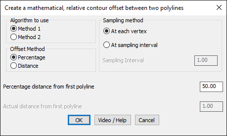
Offset Calculation Methods:
- Method 1: Uses the primary algorithm for determining the offset polyline positions.
- Method 2: Provides an alternative algorithm for cases where Method 1 does not yield satisfactory results.
Offset Methods:
- Percentage Offset: The offset polyline is placed at a user-specified percentage distance between the first and second polylines.
- Absolute Distance Offset: The offset polyline is placed at an exact measured distance from the first polyline toward the second.
Sampling Methods for Vertex Placement:
- At Each Vertex: The new offset polyline inherits the exact number of vertices from the first source polyline.
- At Sampling Interval: The first polyline is sampled at a fixed interval, and for each sampled point, a corresponding offset polyline point is generated.
Configurable Parameters for Precision Control:
- Sampling Interval: Defines the interval at which the first polyline is sampled for generating offset points.
- Percentage Distance from First Polyline: Allows defining the offset as a percentage of the distance between the two source polylines.
- Actual Distance from First Polyline: Allows defining the offset as an absolute measured distance from the first polyline.
Benefits:
- Automates the creation of intermediate contour lines for DEM (Digital Elevation Models) and GIS applications.
- Ensures precise interpolation of contour elevations between two known contour lines.
- Provides multiple calculation methods to handle varying polyline geometries.
- Supports topographic mapping, terrain analysis, and hydrological modeling.
- Helps in contour smoothing, slope analysis, and surface modeling.
This tool is particularly useful for surveyors, GIS professionals, and civil engineers working on terrain-based projects, infrastructure planning, and digital elevation processing.