Summary
The GT_UPDATEPOINTBLK command is specifically designed for surveyors and CAD professionals working with coordinate-based blocks in BricsCAD, AutoCAD, ZWCAD and ARES Commander. It allows users to update attribute values within a point block that contains Easting, Northing, and Elevation (Z) data.
GeoTool -> Blocks Tools -> Blocks Tools -> Update ‘Coordinates Block’ attributes
Update ‘Coordinates Block’ Attributes: GT_UPDATEPOINTBLK – GeoTools Command
Update ‘Coordinates Block’ Attributes: GT_UPDATEPOINTBLK – GeoTools Command
Key Features Include:
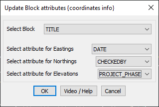
Block & Attribute Selection:
- Select Block: Choose the point block that contains coordinate-related attributes.
- Select Attribute for Eastings: Assign the attribute that stores Easting (X) coordinates.
- Select Attribute for Northings: Assign the attribute that stores Northing (Y) coordinates.
- Select Attribute for Elevations: Assign the attribute that stores Elevation (Z) values.
Automatic Data Population:
- Once attributes are assigned, the command automatically updates each block instance with the correct coordinate values.
- Ideal for surveying, GIS, and mapping workflows where point data needs to be dynamically updated.
Supports Various CAD Workflows:
- Works seamlessly with survey point blocks, GIS data, topographic maps, and other CAD-based geospatial applications.
- Can be used for batch updating multiple blocks within a drawing, ensuring consistency.
Benefits:
- Automates Coordinate Entry – Reduces manual input errors when handling large datasets.
- Enhances Accuracy – Ensures that all points maintain correct Easting, Northing, and Elevation values.
- Saves Time – Eliminates the need for manually editing block attributes.
- Ideal for Surveying & GIS Workflows – Perfect for civil engineering, land survey, and topographical mapping projects.
The GT_UPDATEPOINTBLK command is a valuable tool for surveyors, civil engineers, and GIS professionals who require accurate and efficient coordinate attribute management in their CAD drawings.