Summary
The GT_DATAMAN command is a data management tool within BricsCAD, AutoCAD, ZWCAD and ARES Commander, designed to define, store, and manage object-related metadata using Extended Entity Data (XDATA) within a CAD drawing. This feature enables users to create a database structure within CAD files, ensuring metadata is linked directly to drawing objects.
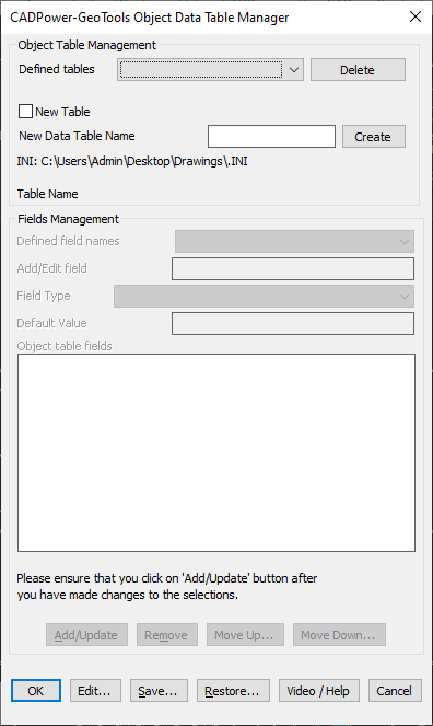
GeoTool -> GeoTools Object Table Data Tools -> GeoTools Object Table Data Tools -> Object Data Manager
Key Features Include:
1. Object Table Management
- Allows creation, selection, and deletion of object data tables.
- Uses an INI-based system to define database structures.
- Stores metadata within XDATA, eliminating the need for external databases.
2. Field Management
- Enables users to add, edit, remove, or reorder fields within an object data table.
- Supports various data types such as:
- String (Text-based information)
- Real (Floating point numerical values)
- Integer (Whole numbers)
- Link (File reference linking CAD objects to external files)
3. Data Storage & Accessibility
- All data is stored in XDATA, ensuring it remains within the drawing file.
- The GT_DATAMAN INI file defines the database structure, making it portable and easily configurable.
- Objects with associated XDATA can be queried, exported, or linked to external files.
4. Linking External Files
- Supports associating CAD objects with external files such as images, PDFs, reports, and spreadsheets.
- Provides browse and show options, allowing users to open linked files directly from within CAD.
5. Customization & Flexibility
- Users can define their own database schema tailored to project-specific needs.
- Provides predefined dropdown values for easy data entry.
- Allows multiple object data tables to be defined and managed within a single drawing.
Benefits
- Eliminates the need for external databases by keeping all object-related metadata within the drawing file.
- Improves data management in GIS, infrastructure, and facility management projects.
- Enables better organization of CAD data, making it easier to search, filter, and analyze.
- Enhances interoperability, allowing CAD professionals to integrate non-graphical data with drawing objects.
- Boosts efficiency by reducing manual data input errors and providing structured data fields.
The GT_DATAMAN command is an essential tool for surveyors, engineers, GIS analysts, and CAD managers, ensuring seamless metadata integration within CAD drawings while maintaining data integrity and accessibility.