Summary
The GT_ELEVATESURFACE command in BricsCAD, AutoCAD, ZWCAD and ARES Commander allows users to increase or decrease the elevation of a GeoTools Digital Terrain Model (DTM) surface by a specified vertical distance.
GeoTool -> Civil Tools -> Surfaces -> Change the elevation of a surface
Key Features Include:
- Elevate or Lower a Surface: Adjusts the Z-values of the entire surface model by the user-specified elevation value.
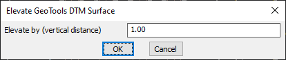
- Precision Control: Allows users to enter an exact vertical offset for uniform elevation adjustments.
- Efficient Terrain Adjustments: Useful for aligning surfaces to new elevation benchmarks, compensating for level shifts, or simulating earthworks.
- Quick and Easy Use: A simple dialog-based interface makes it easy to specify the required elevation change.
Benefits
- Ideal for Terrain Analysis and Engineering Applications where elevation modifications are necessary.
- Helps in Correcting Survey Data Errors by uniformly adjusting surface heights.
- Useful for Infrastructure Design, including roads, drainage, and land development projects.
- Supports Accurate 3D Modeling by maintaining consistency in elevation-based datasets.
With GT_ELEVATESURFACE, users can quickly modify terrain elevations, ensuring seamless integration into GIS, civil engineering, and topographic modeling workflows.