Summary
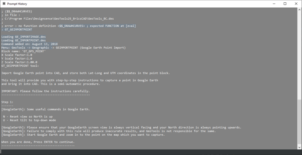
The GT_GEIMPORTPOINT command in BricsCAD, AutoCAD, ZWCAD and ARES Commander is used to import coordinate points from Google Earth into CAD, storing both latitude-longitude and UTM (Universal Transverse Mercator) coordinates in a designated point block. This tool facilitates the integration of geospatial data into CAD drawings, helping users map real-world locations efficiently.
GeoTool -> Geographic Tools -> Geographic Tools -> Google Earth Point Import
Key Features Include:
Seamless Integration with Google Earth
- Allows users to capture coordinate points directly from Google Earth.
- Works with both Lat-Long and UTM coordinate systems for accuracy.
- Ensures proper alignment by guiding users through correct Google Earth settings.
Point Block Creation & Storage
- Uses a predefined block (e.g., GT_GPS_POINT) to store captured points.
- Each point retains Lat-Long, UTM X-Y coordinates, and optional elevation (Z-value).
Scale Factor Control
- Users can define X, Y, and Z scale factors for proper positioning in the CAD drawing.
Step-by-Step Guidance
- Interactive command prompts guide users through the process, ensuring accurate placement.
- Instructs users to reset Google Earth view for proper north alignment before data capture.
Benefits:
- Accurate Georeferencing: Captures precise real-world locations and integrates them seamlessly into CAD.
- Saves Time: Eliminates manual coordinate entry, reducing errors in surveying and mapping projects.
- Supports GIS & Civil Engineering Applications: Essential for topographic mapping, urban planning, and infrastructure design.
- Improved Visualization: Allows users to align their CAD designs with real-world geographic features.
The GT_GEIMPORTPOINT command simplifies geospatial data capture, ensuring accurate mapping, planning, and design within CAD environments