Summary
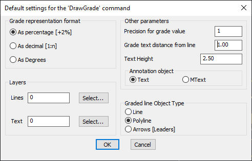
The GT_DRAWGRADE command in GeoTools enables the creation of graded 3D polylines or lines with precise slope control, essential for civil engineering, site grading, and infrastructure design in BricsCAD, AutoCAD, ZWCAD and ARES Commander.
GeoTool -> Geological/Mining Tools -> General -> Draw Graded polylines

Key Features Include:
- Flexible Grade Representation:
- Percentage (+2%)
- Decimal (1:n)
- Degrees
- Multiple Output Object Types:
- 3D Polylines for direct grading representation.
- Lines for simpler slope depiction.
- Leaders with Arrows for annotation-based slope visualization.
- Layer Control: Assign specific layers for graded lines and text annotations.
- Precision Settings: Define grade value precision and text height for clear annotation.
- Customizable Annotation Placement:
- Choose between Text or MText annotation styles.
- Adjust grade text distance from the line for optimal readability.
Benefits:
This tool is perfect for roadway design, landscape modeling, and slope analysis, allowing users to create visually clear and dimensionally accurate grading representations.
