Summary
The GEOL_BOREHOLESTRATA command in GeoTools is used to import, process, and visualize borehole stratigraphy data in CAD environments. It is a critical tool for geologists, mining engineers, and geotechnical professionals working in BricsCAD, AutoCAD, ZWCAD and ARES Commander.
GeoTool -> Geological/Mining Tools -> Bore-Hole -> Draw bore-hole cross-section strata
Key Features Include:
- Borehole Strata Data Import & Processing:
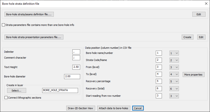
- Load borehole strata/seams definition files from structured CSV data.
- Supports multiple borehole entries in a single parameter file.
- Customize delimiters and comment characters for CSV parsing.
- Strata Column Mapping & Data Positioning:
- Assign column positions for key borehole attributes, including:
- Borehole Name/Number
- Strata Code/Name
- From Level & To Level
- Recovery Percentage & Recovery Total
- Starting Row Number for data extraction
- Assign column positions for key borehole attributes, including:
- Graphical Borehole Representation:
- Specify text height for annotations.
- Define borehole diameter for visual scaling.
- Assign a dedicated CAD layer (e.g., BORE_HOLE_STRATA) for structured data visualization.
- Option to connect lithographic sections for continuous geological interpretation.
- Visualization & Analysis Tools:
- Draw 2D Section View to display cross-sectional strata in CAD.
- Attach Data to Boreholes for enhanced geospatial analysis.
Benefits:
This tool is ideal for subsurface geological modeling, mining exploration, and soil profile analysis, providing an efficient way to interpret borehole stratigraphy in CAD.