Summary
The GT_SURFAREA command in GeoTools calculates the surface area of selected 3DFACE or SOLID objects, making it a valuable tool for civil engineers, surveyors, and GIS professionals working in BricsCAD, AutoCAD, ZWCAD and ARES Commander.
GeoTool -> Miscellaneous Tools -> Miscellaneous Tools -> Compute Surface Area of 3DFACEs
Key Features Include:
- Accurate Surface Area Computation:
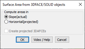
- Compute actual surface area based on 3D slopes.
- Calculate the horizontally projected area for planimetric analysis.
- Projection Options:
- Option to create projected 3DFACEs on the XY plane, providing a clear 2D representation of the 3D surface.
- Ideal for Various Applications:
- Terrain and land area analysis in topography and site planning.
- Excavation and volume estimation for construction projects.
- GIS and survey data processing for accurate mapping.
Benefits:
This tool enhances 3D surface analysis by providing both true and projected area measurements, ensuring accurate data representation in CAD environments.