Summary
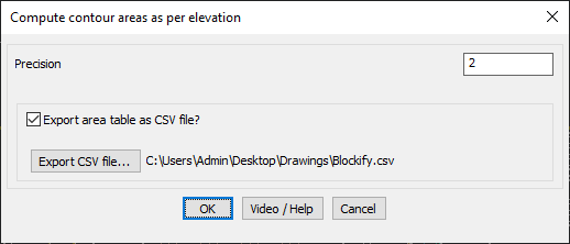
The GT_CONTAREATABLE command in GeoTools calculates contour areas based on elevation and provides the option to export the area data as a CSV file. This tool is essential for surveyors, GIS professionals, and civil engineers working in BricsCAD, AutoCAD, ZWCAD and ARES Commander.
GeoTool -> Miscellaneous Tools -> Miscellaneous Tools ->Contour Area Table / CSV
Key Features Include:
- Compute Contour Areas by Elevation:
- Analyzes contour polylines and calculates their enclosed areas.
- Supports user-defined precision for accurate area computations.
- Export Area Data to CSV:
- Option to save the computed contour area table as a CSV file.
- Allows users to specify the export file location for easy data access.
- Practical Applications:
- Topographic and land-use analysis for contour-based mapping.
- Watershed and terrain analysis in GIS and environmental studies.
- Earthwork estimation for construction and site grading.
Benefits:
This tool streamlines contour-based area calculations while ensuring structured data export for further analysis.