Summary
The GT_PLFILTER command in GeoTools provides a powerful method for filtering polylines based on their geometric and attribute properties, making it a useful tool for surveyors, GIS professionals, and CAD drafters in BricsCAD, AutoCAD, ZWCAD and ARES Commander.
GeoTool -> Selection Tools -> Selection Tools -> Polylines based on properties
Key Features Include:
- Comprehensive Polyline Filtering Options:
- 2D or 3D Polylines
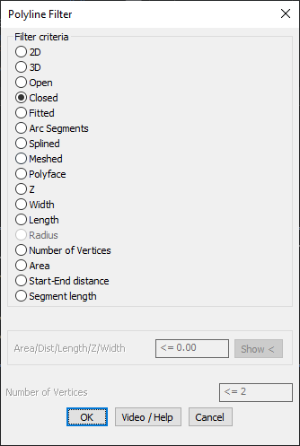
- Open or Closed Polylines
- Fitted, Arc Segments, Splined, Meshed, or Polyface Polylines
- Attribute-Based Filtering:
- Z Value (Elevation-based filtering)
- Width & Length
- Number of Vertices
- Area
- Start-End Distance
- Segment Length
- Advanced Selection Criteria:
- Apply logical operators to refine selection:
< n(Less than)<= n(Less than or equal to)> n(Greater than)>= n(Greater than or equal to)= n(Equal to)/= n(Not equal to)
- Example: Selecting polylines with area ≤ 55.0 ensures only relevant objects are included.
- Apply logical operators to refine selection:
- Practical Applications:
- Extract specific contour polylines based on Z-values.
- Filter polylines by length, area, or vertex count for simplified analysis.
- Isolate closed polylines for boundary detection in GIS and land mapping.
Benefits:
This tool helps optimize selection and modification of polylines, improving workflow efficiency in CAD environments.