Summary
The GT_DWG_STAT command in GeoTools provides a detailed statistical report of the current drawing, making it an essential tool for CAD managers, drafters, and engineers working in BricsCAD, AutoCAD, ZWCAD and ARES Commander.
GeoTool -> Inquiry Tools -> Inquiry Tools -> Display Drawing Statistics
Key Features Include:
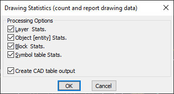
- Comprehensive Drawing Statistics Report:
- Layer Statistics – Counts and lists all layers in the drawing.
- Object (Entity) Statistics – Provides a breakdown of entity types (lines, polylines, circles, blocks, etc.).
- Block Statistics – Counts and lists block definitions used in the drawing.
- Symbol Table Statistics – Summarizes text styles, dimension styles, and other symbol table elements.
- Export Data as a CAD Table:
- Option to generate a CAD table output for easy reference within the drawing.
- Useful for documentation, auditing, and quality control.
Benefits:
This tool helps in analyzing and managing complex drawings, improving workflow efficiency and drawing organization.