Customize Consent Preferences

We use cookies to help you navigate efficiently and perform certain functions. You will find detailed information about all cookies under each consent category below.

The cookies that are categorized as "Necessary" are stored on your browser as they are essential for enabling the basic functionalities of the site. ... 

Always Active

Necessary cookies are required to enable the basic features of this site, such as providing secure log-in or adjusting your consent preferences. These cookies do not store any personally identifiable data.

No cookies to display.

Functional cookies help perform certain functionalities like sharing the content of the website on social media platforms, collecting feedback, and other third-party features.

No cookies to display.

Analytical cookies are used to understand how visitors interact with the website. These cookies help provide information on metrics such as the number of visitors, bounce rate, traffic source, etc.

No cookies to display.

Performance cookies are used to understand and analyze the key performance indexes of the website which helps in delivering a better user experience for the visitors.

No cookies to display.

Advertisement cookies are used to provide visitors with customized advertisements based on the pages you visited previously and to analyze the effectiveness of the ad campaigns.

No cookies to display.

GeoTools

Alignment (Cut/Fill) Volume: GT_ALIGNMENTCF – GeoTools Command

Summary

The GT_ALIGNMENTCF command in GeoTools performs cut and fill volume analysis by comparing two cross-sectional profiles. It is a critical tool for earthwork estimation, excavation planning, and grading analysis in BricsCAD, AutoCAD, ZWCAD and ARES Commander.

GeoTool -> Geological/Mining Tools -> General -> Alignment (Cut/Fill) Volume

Alignment (Cut/Fill) Volume: GT_ALIGNMENTCF – GeoTools Command

Key Features Include:

  • Automated Cut/Fill Computation:
    • Analyzes cross-sections generated using the GT_CROSSSECT command.
    • Compares the existing ground profile with the finished grade alignment.
    • Computes and visually represents cut and fill areas with color coding.
  • Customizable Volume Calculation:
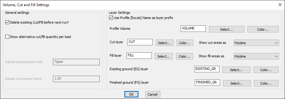
    • Report volumes in cubic units or as vehicle loads (e.g., tippers).
    • Define volume measurement units and set a conversion factor for accurate excavation estimates.
  • Layer Management & Visualization:
    • Assign specific layers for cut, fill, existing ground, and finished ground.
    • Display cut and fill areas as polylines for better visualization.
    • Use the profile name as a layer prefix for structured data organization.
  • 3D Finished Ground Profile Creation:
    • Generates an updated 3D polyline representing the finished ground level.
    • Maintains a linked relationship with the original existing ground polyline for continuity in design.

Benefits:

This command is essential for roadway design, land development, and infrastructure projects, enabling engineers to efficiently calculate and manage earthwork operations.

Leave a Comment

Your email address will not be published. Required fields are marked *