Summary
The GT_ZTREND command in GeoTools ensures that 3D polylines maintain a consistent elevation flow, either upwards or downwards, in BricsCAD, AutoCAD, ZWCAD and ARES Commander.
GeoTool -> Drawing Cleanup Tools -> Drawing Cleanup Tools -> Analyze and fix polyline elevation trends
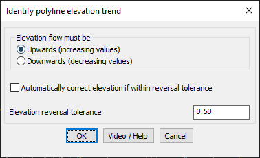
Analyze and Fix Polyline Elevation Trends: GT_ZTREND – GeoTools Command
Key Features Include:
- Elevation Flow Validation:
- Upwards (Increasing Values) – Ensures that vertex elevations increase consistently.
- Downwards (Decreasing Values) – Ensures that vertex elevations decrease consistently.
- Automatic Elevation Correction:
- Detects temporary elevation reversals within a specified tolerance and automatically corrects them if enabled.
- Elevation Reversal Tolerance:
- Defines the acceptable deviation range where slight reversals can be adjusted.
- Closed Polyline Processing:
- Option to include closed polylines in elevation trend analysis.
- Detailed Reporting & Visualization:
- Identifies incorrect elevation trends and creates point objects in a temporary layer to mark inconsistencies.
- Generates an ASCII report file with complete statistics, including:
- Number of vertices checked.
- Errors found, fixed, or ignored.
Benefits:
This tool is essential for surveying, terrain modeling, and GIS applications, ensuring accurate elevation consistency in 3D polylines.