Summary
The GT_ASS_EL_AUTO command in GeoTools automatically assigns elevation values to contour polylines by extracting numeric values from nearby elevation text objects in BricsCAD, AutoCAD, ZWCAD and ARES Commander.
GeoTool -> Conversion Tools -> Conversion Tools -> Assign contour elevations automatically (text->contour polyline)
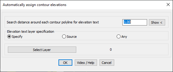
Assign Contour Elevations Automatically (Text->Contour Polyline): GT_ASS_EL_AUTO – GeoTools Command
Key Features Include:
- Automatic Elevation Assignment for Contour Polylines:
- Searches for text labels near contour polylines and assigns the corresponding elevation.
- Customizable Search Distance:
- Defines a search radius around polylines to locate elevation text.
- Elevation Text Layer Specification:
- Specify – Select a specific layer for elevation text.
- Source – Uses the layer of the contour polylines to find elevation text.
- Any – Searches across all layers for elevation text.
- Layer Selection Option:
- Users can choose a specific layer for text extraction using the “Select Layer” button.
Benefits:
This tool simplifies contour mapping and topographic modeling, ensuring accurate and efficient elevation assignments for contour polylines.