Customize Consent Preferences

We use cookies to help you navigate efficiently and perform certain functions. You will find detailed information about all cookies under each consent category below.

The cookies that are categorized as "Necessary" are stored on your browser as they are essential for enabling the basic functionalities of the site. ... 

Always Active

Necessary cookies are required to enable the basic features of this site, such as providing secure log-in or adjusting your consent preferences. These cookies do not store any personally identifiable data.

No cookies to display.

Functional cookies help perform certain functionalities like sharing the content of the website on social media platforms, collecting feedback, and other third-party features.

No cookies to display.

Analytical cookies are used to understand how visitors interact with the website. These cookies help provide information on metrics such as the number of visitors, bounce rate, traffic source, etc.

No cookies to display.

Performance cookies are used to understand and analyze the key performance indexes of the website which helps in delivering a better user experience for the visitors.

No cookies to display.

Advertisement cookies are used to provide visitors with customized advertisements based on the pages you visited previously and to analyze the effectiveness of the ad campaigns.

No cookies to display.

GeoTools

Assign Interpolated Z Values to Vertices: GT_PL_INTER – GeoTools Command

Summary

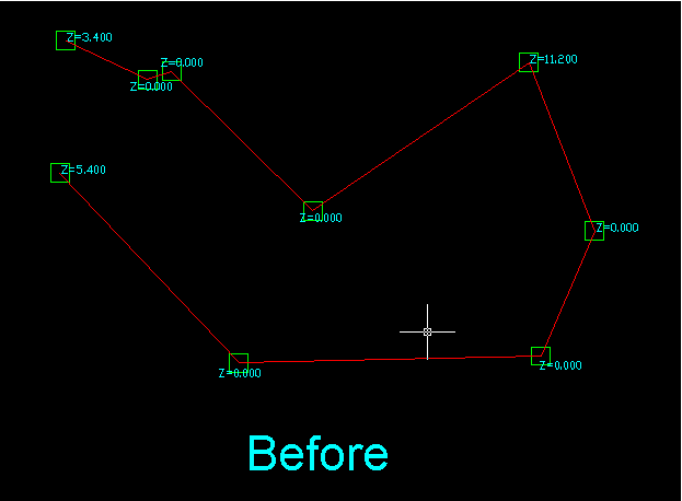
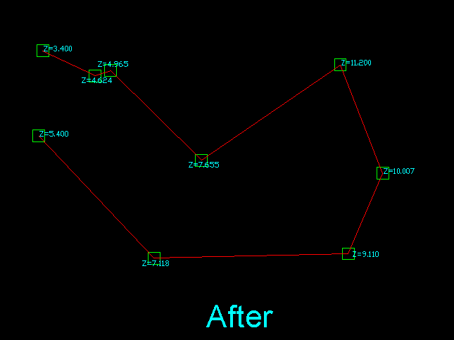
The GT_PL_INTER command in GeoTools is designed to interpolate missing elevation values (Z) in polylines, ensuring smooth elevation transitions within BricsCAD, AutoCAD, ZWCAD and ARES Commander.

GeoTool -> Polyline Tools -> Process -> Assign Interpolated Z values to vertices

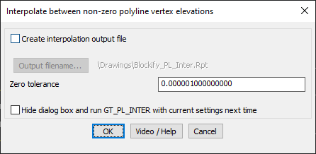
Assign Interpolated Z values to vertices: GT_PL_INTER – GeoTools Command

Assign Interpolated Z Values to Vertices: GT_PL_INTER – GeoTools Command

Key Features Include:

  • Automatic Elevation Interpolation – Assigns interpolated Z values to vertices with zero elevation based on adjacent non-zero elevation points.
  • Linear Distance Interpolation – Uses a proportional method to estimate missing Z values between existing non-zero vertices.
  • Custom Zero Tolerance – Allows defining a threshold for treating near-zero values as zero.
  • Optional Output File Generation:
    • Create Interpolation Report – Saves the results in a text file for analysis.
    • User-Defined Output Path – Specify a custom location for saving interpolation data.
  • Run in Silent Mode – Option to hide the dialog and execute the command with pre-set configurations.

Benefits:

This tool is highly beneficial for topographic modeling, GIS applications, and infrastructure design, where maintaining consistent elevation data is crucial.

Examples:

Leave a Comment

Your email address will not be published. Required fields are marked *