Summary
The GT_ASN_PROP command in GeoTools allows users to assign elevation or thickness properties to selected points, polylines, lines, shapes, blocks, or circles by inheriting values from nearby text objects or block attributes in BricsCAD, AutoCAD, ZWCAD and ARES Commander.
GeoTool -> Conversion Tools -> Conversion Tools -> Assign Properties
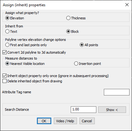
Assign Properties: GT_ASN_PROP – GeoTools Command
Assign Properties: GT_ASN_PROP – GeoTools Command
Assign Properties: GT_ASN_PROP – GeoTools Command
Key Features Include:
Key Features & Functionality:
- Assign Elevation or Thickness Properties:
- Elevation – Inherits Z-values from nearby text or block attributes.
- Thickness – Assigns thickness values from reference objects.
- Choose Inheritance Source:
- Text – Searches for nearby text objects to derive values.
- Block – Extracts values from block attributes based on a specified attribute tag name.
- Polyline Elevation Assignment Options:
- First and Last Points Only – Assigns elevation to only the start and end points of selected polylines.
- All Points – Assigns elevation to each vertex of a polyline.
- Measurement Distance Options:
- Nearest Visible Location – Searches for the nearest visible part of text/block within the defined search distance.
- Insertion Point – Searches for text or blocks with an insertion point within the search distance.
- Advanced Control Options:
- Convert 2D Polylines to 3D Automatically – Upgrades 2D polylines to 3D when elevation is assigned.
- Inherit Property Only Once – Ensures that the same object does not inherit the property multiple times.
- Delete Inherited Object – Removes the text or block after its property is inherited.
- Search Distance Control:
- Define a search radius to locate text or block attributes for property assignment.
Benefits:
This tool is particularly useful for surveying, GIS mapping, and CAD modeling, where properties such as elevation or thickness need to be efficiently assigned to geometry.