Customize Consent Preferences

We use cookies to help you navigate efficiently and perform certain functions. You will find detailed information about all cookies under each consent category below.

The cookies that are categorized as "Necessary" are stored on your browser as they are essential for enabling the basic functionalities of the site. ... 

Always Active

Necessary cookies are required to enable the basic features of this site, such as providing secure log-in or adjusting your consent preferences. These cookies do not store any personally identifiable data.

No cookies to display.

Functional cookies help perform certain functionalities like sharing the content of the website on social media platforms, collecting feedback, and other third-party features.

No cookies to display.

Analytical cookies are used to understand how visitors interact with the website. These cookies help provide information on metrics such as the number of visitors, bounce rate, traffic source, etc.

No cookies to display.

Performance cookies are used to understand and analyze the key performance indexes of the website which helps in delivering a better user experience for the visitors.

No cookies to display.

Advertisement cookies are used to provide visitors with customized advertisements based on the pages you visited previously and to analyze the effectiveness of the ad campaigns.

No cookies to display.

GeoTools

Contour Spacing Distance Tool: GT_CONTDIST – GeoTools Command

Summary

The GT_CONTDIST command in GeoTools is a powerful tool for checking contour spacing and breaking contours where adjacent contour lines are too close together. This is particularly useful for cartographers, civil engineers, and surveyors working with BricsCAD, AutoCAD, ZWCAD and ARES Commander.

GeoTool -> Miscellaneous Tools -> Miscellaneous Tools -> Contour Spacing Distance Tool

Contour Spacing Distance Tool: GT_CONTDIST – GeoTools Command

Key Features Include:

  • Contour Spacing Checker & Breaker:
    • Identifies locations where contours are too close together, making them difficult to read or label.
    • Automatically breaks contour polylines at points where spacing is less than the specified tolerance.
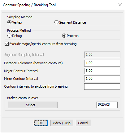
  • Flexible Sampling Methods:
    • Vertex-based sampling – Checks contour spacing at each vertex.
    • Segment distance-based sampling – Analyzes spacing at regular intervals along the contour.
  • Contour Breaking Options:
    • Distance Tolerance Control – Users can define the minimum spacing required between adjacent contours.
    • Major & Minor Contour Intervals – Helps in distinguishing between different contour types.
    • Exclusion of Major Contours – Prevents breaking of primary contour lines and user-specified elevation levels.
  • Efficient Layer Management:
    • Allows users to specify a layer for broken contour segments to keep drawing data organized.

Benefits:

This tool is particularly useful for terrain mapping, topographic visualization, and automated contour refinement, ensuring clear contour representation and uncluttered labeling in CAD drawings.

Leave a Comment

Your email address will not be published. Required fields are marked *