Summary
The GT_0LEN2PNT command in GeoTools converts all zero-length lines, polylines, and 3D faces into point objects, making them easier to identify and manage in BricsCAD, AutoCAD, ZWCAD and ARES Commander.
GeoTool -> Conversion Tools -> Conversion Tools -> Convert 0 Lengths to POINTs
Key Features Include:
- Detects and Converts Zero-Length Entities:
- Processes lines, polylines, and 3D faces with zero length.
- Converts these redundant objects into points for easy identification.
- Elevation Handling:
- The created points are assigned an elevation based on the average of all the vertices in the source object.
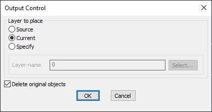
- Layer Placement Options:
- Source Layer – Places the new points in the same layer as the original object.
- Current Layer – Inserts the points in the active working layer.
- Specify Custom Layer – Allows users to define a specific layer for the points.
- Option to Delete Original Objects:
- Users can remove the original zero-length objects after conversion to keep the drawing clean.
- Preserves Extended Entity Data (XData):
- If the source objects contain XData or object table data, it is transferred to the new points.
Benefits:
This tool is essential for cleaning up redundant data that may arise from CAD imports, modeling errors, or 3D face processing, ensuring a more efficient drawing environment.