Customize Consent Preferences

We use cookies to help you navigate efficiently and perform certain functions. You will find detailed information about all cookies under each consent category below.

The cookies that are categorized as "Necessary" are stored on your browser as they are essential for enabling the basic functionalities of the site. ... 

Always Active

Necessary cookies are required to enable the basic features of this site, such as providing secure log-in or adjusting your consent preferences. These cookies do not store any personally identifiable data.

No cookies to display.

Functional cookies help perform certain functionalities like sharing the content of the website on social media platforms, collecting feedback, and other third-party features.

No cookies to display.

Analytical cookies are used to understand how visitors interact with the website. These cookies help provide information on metrics such as the number of visitors, bounce rate, traffic source, etc.

No cookies to display.

Performance cookies are used to understand and analyze the key performance indexes of the website which helps in delivering a better user experience for the visitors.

No cookies to display.

Advertisement cookies are used to provide visitors with customized advertisements based on the pages you visited previously and to analyze the effectiveness of the ad campaigns.

No cookies to display.

GeoTools

Convert Arc Polylines to Linear Segment Polyline: GT_PLARC2PL – GeoTools Command

Summary

The GT_PLARC2PL command in GeoTools converts arc segments within polylines or ARC objects into polylines with linear interpolated segments, maintaining accurate representation in BricsCAD, AutoCAD, ZWCAD and ARES Commander.

GeoTool -> Conversion Tools -> Conversion Tools -> Convert Arc Polylines to linear segment polylinenes

Convert Arc Polylines to Linear Segment Polyline: GT_PLARC2PL – GeoTools Command

Convert Arc Polylines to Linear Segment Polyline: GT_PLARC2PL – GeoTools Command

Key Features Include:

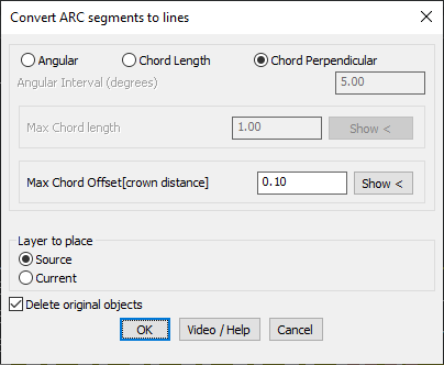
  • Three Arc Approximation Methods:
    • Angular Interval – Converts arcs into linear segments at specified angular intervals (degrees). Ideal for geometric replacements at fixed angles.
    • Chord Length – Approximates the arc using line segments with a maximum chord length, ensuring controlled segment density.
    • Chord Perpendicular (Crown Distance) – Limits the maximum deviation from the arc to the chord midpoint, providing the most precise arc interpolation for survey and engineering applications.
  • Layer Placement Control:
    • Source Layer – Places the converted polyline in the original object’s layer.
    • Current Layer – Places the converted polyline in the active layer.
  • Option to Delete Original Objects:
    • Choose to remove the source arc/polyline after conversion for a cleaner workspace.

Use Cases:

  • Topographical mapping & surveying where polyline arcs must be represented as straight-line segments.
  • CNC machining & digital fabrication where linearized polylines are required.
  • Road alignments & infrastructure planning needing accurate arc approximations.

Benefits:

This tool is essential for engineers, surveyors, and CAD professionals who require precision in converting arcs into straight-line segments while retaining geometric accuracy.

Leave a Comment

Your email address will not be published. Required fields are marked *