Summary
The GT_BLKSHP2P command in GeoTools allows users to convert block insertions, shapes, text, and circle centers into points, ensuring a streamlined workflow within BricsCAD, AutoCAD, ZWCAD and ARES Commander.
GeoTool -> Conversion Tools -> Conversion Tools -> Convert Blocks/Shapes/Text/Circle to Points
Key Features Include:
- Creates Points at Object Insertion or Center Locations:
- Generates point entities at the insertion point of each selected block, shape, or text object.
- For circles, points are placed at the geometric center.
- Preserves Extended Entity Data:
- If the source objects contain extended entity data (XData) or object table data, it is transferred to the newly created points.
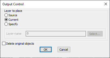
- Layer Placement Options:
- Source Layer – Places the new points in the same layer as the original object.
- Current Layer – Places the points in the active working layer.
- Specify Custom Layer – Allows users to define a specific layer for the created points.
- Option to Delete Original Objects:
- Users can choose to delete the source objects (blocks, shapes, text, circles) after point conversion for a cleaner drawing.
Use Cases:
- GIS and Surveying Applications – Converting block-based markers into points for better data management.
- Topographic Mapping – Extracting point locations from text or symbols.
- CAD Data Cleanup – Simplifying drawings by replacing block insertions, shapes, or text objects with point markers.
Benefits:
This tool is essential for surveyors, GIS professionals, and CAD users looking to extract point data efficiently from various entity types.