Summary
The GT_LINE2PL command in GeoTools allows users to convert LINE, ARC, and CIRCLE objects into polylines, ensuring better control and editability within BricsCAD, AutoCAD, ZWCAD and ARES Commander.
GeoTool -> Conversion Tools -> Conversion Tools -> Convert LINE and ARC to Polylines
Key Features Include:
- Converts Various Geometry Types:
- Transforms LINE, ARC, and CIRCLE objects into polyline entities.
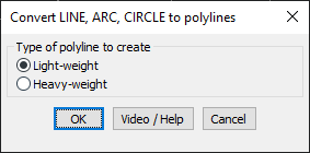
- Polyline Type Selection:
- Lightweight Polyline – Uses optimized storage, reducing file size and improving performance.
- Heavyweight Polyline – Retains additional entity data, useful for specific CAD operations.
- Preserves Geometric Integrity:
- Maintains the shape and accuracy of the original objects during conversion.
Benefits:
This tool is essential for CAD professionals working on map digitization, road alignments, and engineering drawings, ensuring seamless integration and modification of linear and curved entities.