Customize Consent Preferences

We use cookies to help you navigate efficiently and perform certain functions. You will find detailed information about all cookies under each consent category below.

The cookies that are categorized as "Necessary" are stored on your browser as they are essential for enabling the basic functionalities of the site. ... 

Always Active

Necessary cookies are required to enable the basic features of this site, such as providing secure log-in or adjusting your consent preferences. These cookies do not store any personally identifiable data.

No cookies to display.

Functional cookies help perform certain functionalities like sharing the content of the website on social media platforms, collecting feedback, and other third-party features.

No cookies to display.

Analytical cookies are used to understand how visitors interact with the website. These cookies help provide information on metrics such as the number of visitors, bounce rate, traffic source, etc.

No cookies to display.

Performance cookies are used to understand and analyze the key performance indexes of the website which helps in delivering a better user experience for the visitors.

No cookies to display.

Advertisement cookies are used to provide visitors with customized advertisements based on the pages you visited previously and to analyze the effectiveness of the ad campaigns.

No cookies to display.

GeoTools

Convert Points/Text/Circles to Blocks/Shapes: GT_P2BLKSHP – GeoTools Command

Summary

The GT_P2BLKSHP command in GeoTools allows users to replace selected points, text, or circles with blocks or shapes, ensuring a structured and standardized representation in BricsCAD, AutoCAD, ZWCAD and ARES Commander.

GeoTool -> Conversion Tools -> Conversion Tools -> Convert Points/Text/Circles to Blocks/Shapes

Convert Points/Text/Circles to Blocks/Shapes: GT_P2BLKSHP – GeoTools Command

Key Features Include:

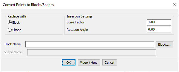
  • Replace Points with Blocks or Shapes:
    • Block Mode – Replaces points with a specified block.
    • Shape Mode – Converts points into a predefined shape.
  • Customizable Insertion Settings:
    • Scale Factor – Adjust the size of the inserted block or shape.
    • Rotation Angle – Set the rotation of the inserted block or shape.
  • Block & Shape Selection:
    • Block Name – Choose a block from the drawing using the “Blocks” button.
    • Shape Name – Enter a shape name for insertion.
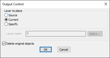
  • Layer Placement Options:
    • Source Layer – Inserts new blocks/shapes into the same layer as the original object.
    • Current Layer – Places new blocks/shapes in the active working layer.
    • Specify Layer – Allows users to define a custom layer for placement.
  • Option to Delete Original Objects:
    • Users can delete the source objects (points, text, circles) after conversion for a cleaner drawing.
  • Retains Extended Entity Data (XData):
    • If the original objects have associated XData or object table data, it is transferred to the new blocks/shapes.

Use Cases:

  • GIS & Surveying – Converting survey points into standard block symbols.
  • Topographic Mapping – Replacing points with marker blocks for better visualization.
  • CAD Drafting Standardization – Ensuring a consistent representation of points across drawings.

Benefits:

This tool is essential for surveyors, GIS professionals, architects, and engineers who need efficient point-to-block conversions for structured CAD workflows.

Leave a Comment

Your email address will not be published. Required fields are marked *