Summary
The GT_SPL2PL command in GeoTools allows users to convert spline curves into polylines using multiple interpolation methods, providing flexibility and precision in BricsCAD, AutoCAD, ZWCAD and ARES Commander.
GeoTool -> Conversion Tools -> Conversion Tools -> Convert Splines to polylines
Convert Splines to Polylines: GT_SPL2PL – GeoTools Command
Convert Splines to Polylines: GT_SPL2PL – GeoTools Command
Key Features Include:
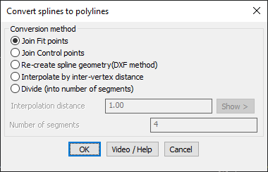
- Multiple Spline-to-Polyline Conversion Methods:
- Join Fit Points – Creates a polyline by connecting the fit points (DXF Code 11) of the spline.
- Join Control Points – Generates a polyline using the control points (DXF Code 10) of the spline.
- Re-create Spline Geometry (DXF Method) – A high-precision method that converts the spline into DXF Release 12 format before reconstructing it as a polyline.
- Interpolate by Inter-Vertex Distance – Defines polyline vertex spacing based on a specified interpolation distance.
- Divide (Number of Segments) – Converts the spline into a polyline by splitting it into a fixed number of segments.
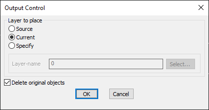
- Layer Placement Options:
- Source Layer – Places the converted polyline in the original spline’s layer.
- Current Layer – Inserts the polyline into the active working layer.
- Specify Custom Layer – Allows users to define a target layer for placement.
- Delete Original Objects (Optional):
- Users can remove the source splines after conversion for a cleaner drawing.
Benefits:
This tool ensures precise spline-to-polyline conversion, improving workflow efficiency in CAD environments.