Summary
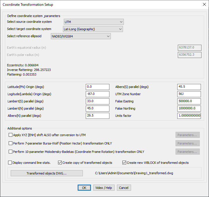
The GT_COORDTRAN_SETUP command in BricsCAD, AutoCAD, ZWCAD and ARES Commander is used for defining coordinate transformation parameters. This tool enables precise conversion between different coordinate systems, such as UTM to Geographic (Lat-Long) or vice versa, using configurable transformation settings.
GeoTool -> Geographic Tools -> Geographic Tools -> Coordinate Transformation Setup
Key Features Include:
- Define Source and Target Coordinate Systems
- Select from common coordinate systems like UTM, Lat-Long, and other projections.
- Supports various datums and reference ellipsoids like NAD83/WGS84 for accurate conversion.
- Reference Ellipsoid Parameters
- Displays important geodetic properties including:
- Earth’s equatorial and polar radius
- Eccentricity and flattening factors
- Ensures correct transformation based on datum properties.
- Displays important geodetic properties including:
- Projection Parameters
- Define key transformation parameters such as:
- Latitude and Longitude Origin
- UTM Zone Number (critical for proper UTM to Geographic conversion)
- False Easting and False Northing (to align with projection grids)
- Scale factors for unit adjustments
- Define key transformation parameters such as:
- Advanced Transformation Options
- XYZ [ENH] Shift: Apply additional shifting adjustments after UTM conversion.
- Bursa-Wolf 7-Parameter Transformation: Used for datum shift and geodetic corrections.
- Molodensky-Badekas 10-Parameter Transformation: Ideal for high-precision coordinate frame rotation.
- Transformation Outputs
- Creates a copy of transformed objects to ensure original data remains intact.
- Option to generate a new WBLOCK of transformed objects for easier data management.
- Saves transformed results in a designated drawing file (DWG) for further use.
Benefits:
- Ensures Geospatial Accuracy: Converts coordinates between different systems while maintaining datum integrity.
- Handles Large-Scale Mapping Projects: Essential for GIS, land survey, and engineering applications requiring precise geolocation.
- Reduces Transformation Errors: Provides multiple transformation methods to match real-world geodetic calculations.
- Flexible Output Options: Saves transformed objects in the current drawing or exports them as separate DWG files for further use.
The GT_COORDTRAN_SETUP command is an indispensable tool for surveyors, GIS professionals, and engineers working with coordinate transformations and geospatial data processing in CAD.