Summary
The GT_INTBUFFER command in GeoTools is designed to generate a buffer (opening) at every intersection of selected entities, ensuring precise clearance management within BricsCAD, AutoCAD, ZWCAD and ARES Commander.
GeoTool -> Polyline Tools -> Identify -> Create a buffer [opening] around each intersection
Key Features Include:
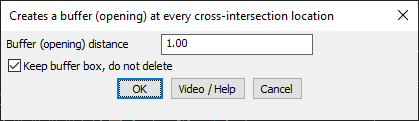
- Automated Buffer Creation – Inserts a buffer around each cross-intersection location.
- Customizable Buffer Distance – Define the buffer size by specifying the desired opening distance.
- Preserve or Remove Buffer Box – Choose to keep the buffer box as a reference or remove it after application.
- Ensures Proper Clearances – Useful for road networks, piping layouts, electrical schematics, and urban planning to maintain spacing at intersections.
Benefits:
This tool is essential for professionals handling engineering designs, infrastructure planning, and network mapping, ensuring proper clearance and intersection management.