Summary
The GT_CREATEGRADING command in BricsCAD, AutoCAD, ZWCAD and ARES Commander is a powerful tool designed for creating grading objects to model slope transitions, earthworks, and site grading conditions efficiently.
GeoTool -> Civil Tools -> Surfaces -> Create a grading object
Key Features Include:
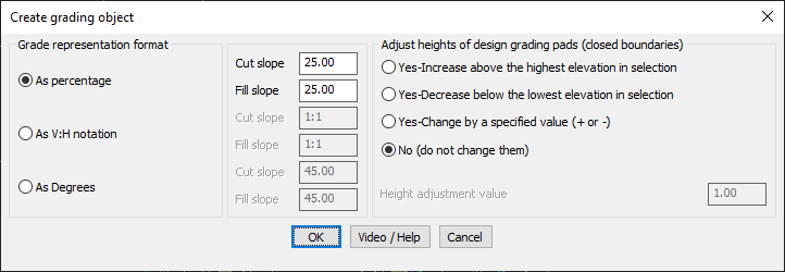
- Customizable Slope Representation: Define slope gradients using:
- Percentage (e.g., 25% slope)
- V:H Ratio Notation (e.g., 1:1)
- Degrees (e.g., 45°)
- Cut and Fill Slopes:
- Specify separate cut and fill slopes for accurate terrain modifications.
- Ensures correct excavation (cut) and embankment (fill) grading.
- Adjust Heights of Grading Pads:
- Increase above the highest elevation in the selection.
- Decrease below the lowest elevation in the selection.
- Adjust by a specified height value for precise grading control.
- Keep existing elevations unchanged, if no modification is needed.
Benefits
- Automates Earthwork Design: Saves time in creating detailed grading plans for landscaping, road design, and site development.
- Enhances Accuracy: Provides precise slope adjustments, reducing errors in terrain modeling.
- Supports Civil & Architectural Projects: Essential for grading pads, embankments, and cut/fill operations.
- Streamlines Site Planning: Quickly generates design slopes to match real-world construction requirements.
With GT_CREATEGRADING, users can design and visualize terrain modifications efficiently, ensuring a smooth transition between existing and proposed ground surfaces.