Summary
The GT_SHEETINS command in BricsCAD, AutoCAD, ZWCAD and ARES Commander enables users to create and insert a structured sheet index block, defining sheet boundaries for mapping and documentation purposes. This tool is essential for managing multiple sheets within large-scale CAD projects, ensuring accurate organization and reference.
GeoTool -> Civil Tools -> Map Sheets -> Create and Place Map Sheet Index Block
Create and Place Map Sheet Index Block: GT_SHEETINS – GeoTools Command
Key Features Include:
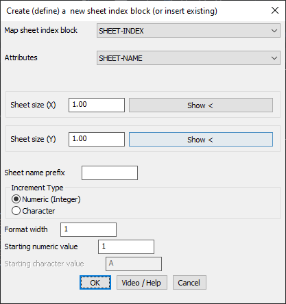
- Map Sheet Index Block Selection
- Choose or define a block to represent sheet boundaries within a map.
- The block serves as a visual reference for layout and plotting.
- Attribute Definition
- Assign attributes (e.g., SHEET-NAME) for easy identification and labeling.
- Helps in systematic sheet numbering and referencing.
- Sheet Size Customization
- Define X (Width) and Y (Height) dimensions for the sheet boundary.
- Adjustable to accommodate various plotting scales and formats.
- Sheet Naming and Numbering
- Assign a prefix to distinguish different sets of sheets.
- Choose an increment type:
- Numeric (Integer) for sequential numbering (1, 2, 3…).
- Character-based for alphabetical ordering (A, B, C…).
- Specify the starting number or character and format width for consistency.
Benefits
- Enhances Drawing Organization: Ensures that large-scale drawings are properly indexed, making it easier to locate specific sheets.
- Standardized Sheet Layouts: Maintains uniform sheet sizes and numbering across projects.
- Simplifies Multi-Sheet Management: Ideal for handling large maps, surveys, and infrastructure drawings with multiple sections.
- Optimized for Printing and Exporting: Ensures sheet boundaries align perfectly for seamless plotting and document production.
With GT_SHEETINS, users can efficiently organize, reference, and manage multi-sheet CAD projects, ensuring clarity and ease of navigation.