Summary
The GT_CREATEANNOT command allows users to generate automated annotations along a selected polyline or linear feature, based on intersecting objects. The annotations are placed perpendicular to the path and can represent layer-based descriptions, interval distances, or cumulative distances.
GeoTool -> Annotation Tools -> Annotation Tools -> Create annotations at Intersections
Create Annotations at Intersections: GT_CREATEANNOT – GeoTools Command
Key Features Include:
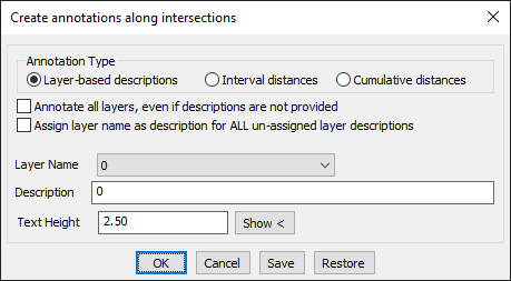
Annotation Type:
- Layer-Based Descriptions: Labels each annotation using the layer description of the intersecting object.
- Interval Distances: Annotations are placed at regular intervals along the polyline.
- Cumulative Distances: Each annotation represents the cumulative distance from the starting point of the polyline.
Customization Options:
- Annotate All Layers: Forces annotation creation even if no descriptions are provided.
- Assign Layer Name as Description: If a layer lacks a description, the layer name is used instead.
Annotation Settings:
- Layer Name: Selects the layer where annotations will be placed.
- Custom Description: Allows manual entry of annotation text.
- Text Height: Adjusts the text size for visibility and readability.
Save & Restore Functionality:
- Save Settings: Saves the current annotation settings for reuse.
- Restore Defaults: Resets to the default configuration.
Benefits:
- Automates the annotation process, saving time and effort.
- Ensures accuracy by dynamically labeling intersecting objects.
- Highly customizable for different annotation styles and workflows.
- Enhances GIS, mapping, and engineering drawings with structured labeling.
- Seamlessly integrates with BricsCAD, AutoCAD, ZWCAD, and ARES Commander.
The GT_CREATEANNOT command is an essential tool for surveying, infrastructure planning, and GIS workflows, ensuring efficient and precise annotation of linear features based on intersections.