Summary
The GT_CREATECENTROID command in GeoTools is used to generate centroid markers inside closed polylines, splines, and circles, enabling better spatial analysis, labeling, and feature identification in BricsCAD, AutoCAD, ZWCAD and ARES Commander.
GeoTool -> Build Tools -> Build Tools -> Create centroid marks inside closed polygons
Create Centroid Marks Inside Closed Polygons: GT_CREATECENTROID – GeoTools Command
Key Features Include:
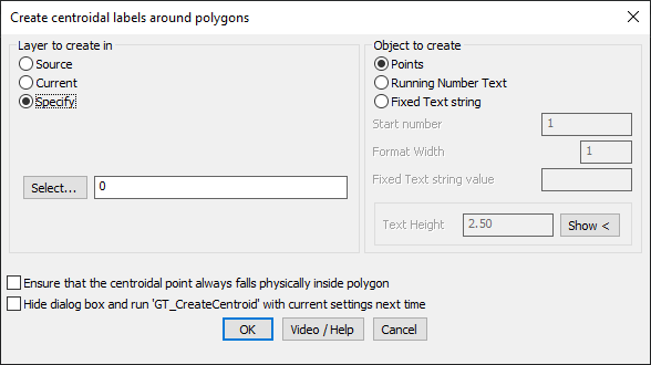
- Layer Selection for Centroid Creation:
- Source: Places centroid markers in the same layer as the closed polyline.
- Current: Creates all centroid markers in the currently active layer.
- Specify: Allows users to choose a custom layer for the centroid markers.
- Object Type Selection:
- Points: Inserts an AutoCAD/BricsCAD point object at the centroid.
- Running Number Text: Creates incrementing numbered text for each centroid.
- Fixed Text String: Assigns a constant text label to each centroidal mark.
- Customization Options:
- Start Number: Defines the initial number for running text numbering.
- Format Width: Controls zero-padding for running number text formatting.
- Fixed Text Value: Specifies the constant text string for fixed labeling.
- Text Height: Adjusts the size of text annotations for better visibility.
- Ensure Centroid Falls Inside Polygon:
- If the calculated centroid falls outside the polygon, it is automatically adjusted to ensure it remains within the polygon boundary.
- Command Automation:
- Users can enable command-line mode to run GT_CREATECENTROID without opening the dialog box, streamlining workflows.
Benefits:
- Automates centroid creation for better polygon labeling and spatial analysis.
- Improves GIS, survey, and topographic mapping accuracy.
- Provides flexible text annotation options for parcel, zoning, and land-use mapping.
- Ensures clear feature identification in engineering and architectural designs.
This tool is essential for surveyors, GIS professionals, urban planners, and CAD users working with closed polygonal features requiring centroid-based labeling or analysis.