Summary
The GT_CS-SCANNER command in GeoTools facilitates the extraction of cross-section data along a longitudinal alignment by scanning point data within a defined corridor. It is an essential tool for civil engineers, surveyors, and GIS professionals working on terrain modeling and infrastructure design in BricsCAD, AutoCAD, ZWCAD and ARES Commander.
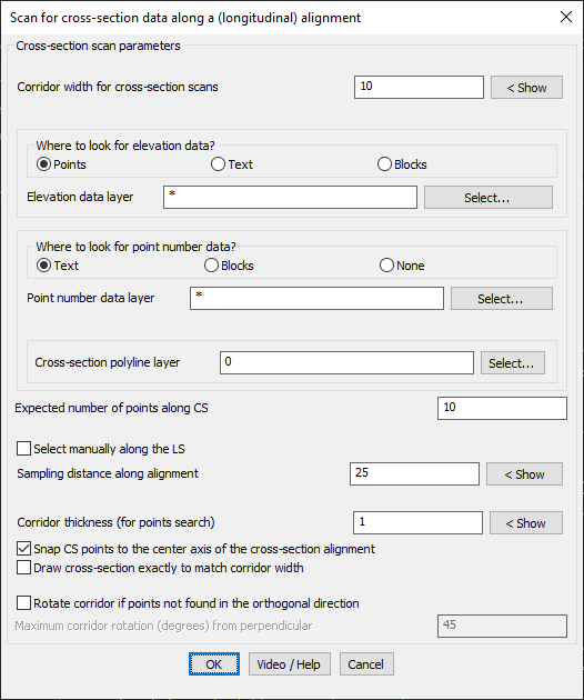
GeoTool -> Geological/Mining Tools -> General -> Create cross-section polyline by scanning points
Key Features Include:
- Flexible Corridor Definition: Set the corridor width for cross-section scans.
- Multiple Data Sources: Extract elevation data from Points, Text, or Blocks.
- Point Number Identification: Identify point numbers from Text, Blocks, or None.
- Layer Selection: Define specific layers for elevation data, point numbers, and cross-section polylines.
- Cross-Section Control:
- Define the expected number of points along the cross-section.
- Manually select cross-section locations along the longitudinal alignment.
- Set the sampling distance for automatic cross-section generation.
- Adjust the corridor thickness for point searches.
- Precision Features:
- Snap cross-section points to the alignment’s center axis.
- Ensure exact cross-section width matches the corridor width.
- Rotate corridor if points are not found in the orthogonal direction, with a customizable rotation limit.
Benefits:
This tool is highly useful for topographic surveys, road and railway design, and hydrological analysis, ensuring precise extraction and visualization of cross-section data for design and analysis.