Summary
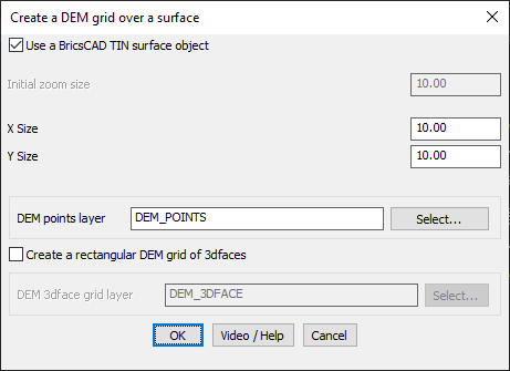
The GT_DEMGRID command is used to generate a DEM (Digital Elevation Model) grid over a selected surface in CAD. This tool can create a grid representation for terrain analysis and modeling, and it supports the use of BricsCAD TIN surfaces or manually input 3D face grids.
GeoTool -> Geological/Mining Tools -> General -> Create DEM Grid
Key Features Include:
- Use BricsCAD TIN Surface
- Option to generate the DEM grid directly from a BricsCAD TIN surface object.
- Grid Size Control
- Initial Zoom Size defines the area of focus when creating the grid.
- X and Y Size set the interval or spacing of grid points in the respective directions.
- DEM Points and Grid Layer Assignment
- Choose a DEM points layer (e.g., DEM_POINTS) to store the point data.
- Optionally, create a rectangular DEM grid using 3dfaces for more detailed representation.
- Customization
- Control the layer for 3D face grids by selecting the appropriate grid layer (e.g., DEM_3DFACE).
Benefits:
This command is vital for tasks involving terrain modeling, earthworks, and other applications requiring detailed elevation grids within CAD platforms.