Customize Consent Preferences

We use cookies to help you navigate efficiently and perform certain functions. You will find detailed information about all cookies under each consent category below.

The cookies that are categorized as "Necessary" are stored on your browser as they are essential for enabling the basic functionalities of the site. ... 

Always Active

Necessary cookies are required to enable the basic features of this site, such as providing secure log-in or adjusting your consent preferences. These cookies do not store any personally identifiable data.

No cookies to display.

Functional cookies help perform certain functionalities like sharing the content of the website on social media platforms, collecting feedback, and other third-party features.

No cookies to display.

Analytical cookies are used to understand how visitors interact with the website. These cookies help provide information on metrics such as the number of visitors, bounce rate, traffic source, etc.

No cookies to display.

Performance cookies are used to understand and analyze the key performance indexes of the website which helps in delivering a better user experience for the visitors.

No cookies to display.

Advertisement cookies are used to provide visitors with customized advertisements based on the pages you visited previously and to analyze the effectiveness of the ad campaigns.

No cookies to display.

GeoTools

Create Map Grid: GT_ANNOGRID – GeoTools Command

Summary

The GT_ANNOGRID command in GeoTools is used to generate a map grid with annotations for a given map sheet, making it an essential tool for cartography, GIS applications, and survey mapping in BricsCAD, AutoCAD, ZWCAD and ARES Commander.

GeoTool -> Geological/Mining Tools -> General -> Create Map Grid

Create Map Grid: GT_ANNOGRID – GeoTools Command

Key Features Include:

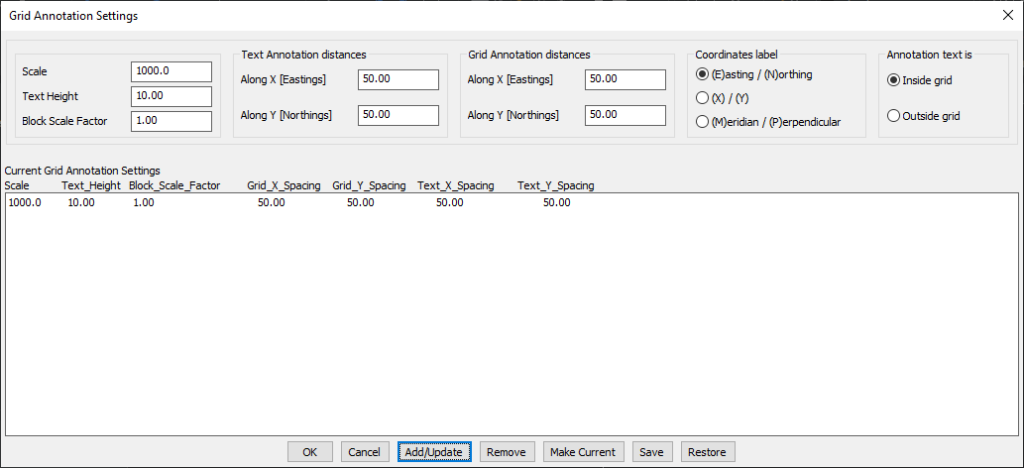
  • Customizable Grid Creation:
    • Define the grid extents by selecting an existing sheet index block (created by GT_SHEETINS) or manually specifying the area.
    • Specify X/Y spacing for grid tick marks and grid annotation text.
  • Flexible Annotation Options:
    • Choose between inside grid or outside grid annotation placement.
    • Customize coordinate labeling formats, including:
      • Easting/Northing (E/N)
      • X/Y Cartesian system
      • Meridian/Perpendicular (M/P)
  • Predefined and Customizable Blocks:
    • Uses pre-defined blocks for grid tick marks and annotations (modifiable for custom styles).
    • Editable block templates include:
      • GRID_CROSS.dwg (grid tick marks)
      • TICK_LEFT.dwg, TICK_RIGHT.dwg, TICK_TOP.dwg, TICK_BOTTOM.dwg (annotation blocks).
  • Scalable Grid Management:
    • Save and manage multiple annotation settings for different map scales.
    • Settings can be stored and restored from ASCII INI files for future use.
    • Set a preferred scale reference without affecting grid parameters.

Benefits:

This tool is ideal for surveyors, cartographers, and GIS professionals who need precise map grid annotation for mapping and documentation.

Leave a Comment

Your email address will not be published. Required fields are marked *