Summary
The GT_TRIANGULATE command in BricsCAD, AutoCAD, ZWCAD and ARES Commander allows users to generate TIN (Triangulated Irregular Network) surfaces or Voronoi polygons from a set of points. This is particularly useful in terrain modeling, GIS, and topographic mapping applications.
GeoTool -> Civil Tools -> Surfaces -> Create TIN Surface (Delauney triangles) / Voronoi polygons
Create TIN Surface (Delauney Triangles) / Voronoi Polygons: GT_TRIANGULATE – GeoTools Command
Key Features Include:
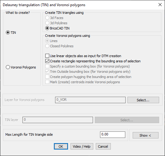
1. TIN (Triangulated Irregular Network) Surface Creation
- Generates 3D faces, 3D polylines, or BricsCAD TIN surfaces from a set of points.
- Ensures efficient terrain representation by forming a network of non-overlapping triangles.
- Allows integration of linear objects (like breaklines) to refine the surface model.
- Option to specify a maximum triangle side length, preventing excessively large triangles in sparse areas.
- Stores surface data externally in a GeoDTM file, ensuring reusability and structured data storage.
2. Voronoi Polygon Creation
- Generates Voronoi polygons from input points using either lines or closed polylines.
- Voronoi diagrams are widely used in spatial analysis to determine influence zones or nearest-neighbor relationships.
- Provides an option to trim Voronoi polygons to a custom bounding box, restricting them to a desired study area.
- Option to generate a bounding rectangle around the selection for better visualization.
- Ability to create centroids inside Voronoi polygons for further spatial processing.
3. Customization & Boundary Definition
- Users can specify a layer for storing Voronoi polygons and TIN surfaces, improving data organization.
- Ability to create a polygon boundary that follows the convex hull of the TIN.
- Supports surface boundary clipping, ensuring that the generated surface remains within the dataset limits.
Benefits
- Essential for Digital Terrain Modeling (DTM) and GIS workflows, enabling precise topographic analysis.
- Provides an accurate surface representation using TINs, ensuring better results in elevation modeling.
- Helps in spatial partitioning using Voronoi diagrams, useful in urban planning, geology, and hydrology studies.
- Prevents unnecessary triangulation outside the dataset bounds, improving model accuracy.
- Streamlines surface processing and analysis, making it a vital tool for surveyors, civil engineers, and GIS professionals.
With GT_TRIANGULATE, users can efficiently model surfaces, analyze spatial relationships, and generate precise terrain representations within CAD environments.