Summary
The GT_LENTEXT command allows users to create and update length or area annotations for various geometric entities such as lines, polylines, arcs, splines, and circles. It enables precise and automated annotation of these properties as text, significantly enhancing CAD detailing and quantity take-offs.
GeoTool -> Annotation Tools -> Annotation Tools -> Create/update length annotation
Create/Update Length Annotation: GT_LENTEXT – GeoTools Command
Key Features Include:
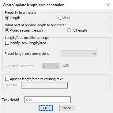
Property to Annotate:
- Length: Measure and annotate the length of an entity, including polylines, lines, arcs, circles, and splines.
- Area: Compute and annotate the enclosed area for closed polylines, splines, and circles.
Length/Area Selection Options:
- Picked Segment Length: Annotates only the length of a selected segment within a polyline.
- Full Length: Annotates the total length of the polyline.
Advanced Annotation Controls:
- Modify DWG Length/Area: Allows users to apply modifications to the length or area values before annotation.
- Preset Length Unit Conversions: Supports unit conversion for automatic adjustments.
- Arithmetic Operator for Adjustments: Apply an arithmetic factor to modify the measured values before annotation.
Text Formatting & Customization:
- Append Length/Area to Existing Text: Adds the computed length or area values to an existing text string, useful for quick data capture.
- Delimiter Selection: Choose a delimiter when appending values to text for better readability.
- Adjustable Text Height: Define text size for better visualization in CAD drawings.
Benefits:
- Automates length and area annotation, eliminating manual measurement errors.
- Supports multiple geometric entities, making it versatile for CAD detailing.
- Enhances quantity take-off workflows by exporting length/area values directly to text.
- Improves efficiency in structural, civil, and architectural CAD documentation.
- Fully compatible with BricsCAD, AutoCAD, ZWCAD, and ARES Commander.
This tool simplifies and speeds up the process of measuring, annotating, and managing length/area properties within CAD drawings, making it an essential feature for professionals handling surveying, drafting, and estimation tasks.