Summary
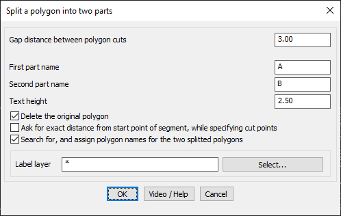
The GT_PolygonCutter command allows users to divide a closed polygon into two separate sections using a slicing line. This is particularly useful for land parcel division, zoning, or GIS-based spatial planning where polygons need to be systematically split.
GeoTool -> Build Tools -> Build Tools -> Cut a Polygon into Two using a Slicing Line
Key Features Include:
Define Cutting Parameters:
- Gap Distance Between Polygon Cuts:
- Specify the gap width between the two newly created polygons after cutting.
- Ensures a visible separation for better distinction.
Automatic Naming of New Polygons:
- First Part Name & Second Part Name:
- Assign unique names to the newly created polygons for easy identification.
- Label Layer Selection:
- Choose a specific layer to store the polygon labels.
Text Settings for Annotation:
- Define text height for the assigned polygon names.
- Labels are placed at the center of each split polygon.
Advanced Splitting Options:
- Delete the Original Polygon:
- Option to automatically remove the original polygon after splitting.
- Specify Exact Cutting Distance:
- Allows users to define an exact split distance from the starting point along the slicing segment.
- Search & Assign Polygon Names Automatically:
- Detects and assigns appropriate names based on predefined attributes or GIS data.
Benefits:
- Ideal for land surveyors, urban planners, and GIS professionals handling property subdivision and spatial adjustments.
- Automates complex polygon splitting tasks, reducing manual workload.
- Ensures precise cuts with minimal effort.
- Fully compatible with BricsCAD, AutoCAD, ZWCAD and ARES Commander, allowing flexible implementation across multiple CAD platforms.
This tool provides a fast and efficient way to divide polygonal regions while maintaining accurate spatial relationships and naming conventions