Summary
The GT_SURFACEVOLUME command in BricsCAD, AutoCAD, ZWCAD and ARES Commander is designed to compute cut and fill volumes between two surfaces or between a surface and a datum reference elevation.
GeoTool -> Civil Tools -> Surfaces -> (Cut/Fill) Volume between surfaces
Key Features Include:
- Compute Cut/Fill Volume: Determines the volume differences between an existing terrain surface and a proposed surface or a fixed elevation datum.
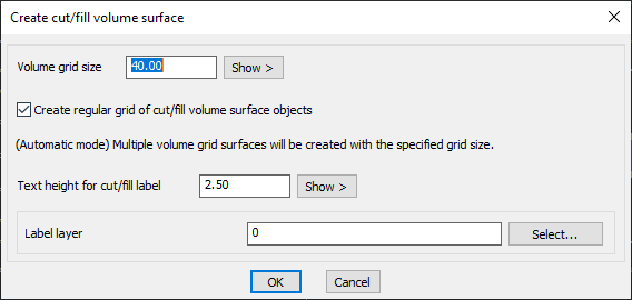
- Grid-Based Volume Calculation: Uses a regular grid method to divide the surface into volume cells, ensuring accurate calculations.
- Automated Processing: In automatic mode, multiple volume grid surfaces are generated using the specified grid size.
- Labeling and Visualization: Allows users to define text height for volume labels, making it easier to visualize cut/fill areas in the drawing.
- Customizable Grid Size: Users can specify the grid size for detailed control over volume calculations, balancing precision and performanc
Benefits
- Accurate Earthwork Estimation: Ideal for site grading, road design, land development, and excavation planning.
- Saves Time and Effort: Eliminates manual volume calculations by automating cut/fill analysis.
- Flexible Surface Comparisons: Works with saved surfaces, allowing comparisons between different survey datasets or design models.
- Supports Engineering and GIS Applications: Essential for civil engineering, construction planning, and topographic studies.
With GT_SURFACEVOLUME, users can efficiently perform earthwork volume analysis, ensuring precise material estimation and cost-effective project planning.