Customize Consent Preferences

We use cookies to help you navigate efficiently and perform certain functions. You will find detailed information about all cookies under each consent category below.

The cookies that are categorized as "Necessary" are stored on your browser as they are essential for enabling the basic functionalities of the site. ... 

Always Active

Necessary cookies are required to enable the basic features of this site, such as providing secure log-in or adjusting your consent preferences. These cookies do not store any personally identifiable data.

No cookies to display.

Functional cookies help perform certain functionalities like sharing the content of the website on social media platforms, collecting feedback, and other third-party features.

No cookies to display.

Analytical cookies are used to understand how visitors interact with the website. These cookies help provide information on metrics such as the number of visitors, bounce rate, traffic source, etc.

No cookies to display.

Performance cookies are used to understand and analyze the key performance indexes of the website which helps in delivering a better user experience for the visitors.

No cookies to display.

Advertisement cookies are used to provide visitors with customized advertisements based on the pages you visited previously and to analyze the effectiveness of the ad campaigns.

No cookies to display.

GeoTools

Delete Duplicate Objects: GT_DELDUP – GeoTools Command

Summary

The GT_DELDUP command in GeoTools removes duplicate entities from the current drawing by applying a specified tolerance to determine duplication in BricsCAD, AutoCAD, ZWCAD and ARES Commander.

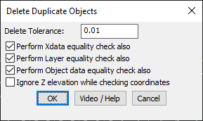
GeoTool -> Drawing Cleanup Tools -> Drawing Cleanup Tools -> Delete Duplicate Objects

Delete Duplicate Objects: GT_DELDUP – GeoTools Command

Key Features Include:

  • Customizable Deletion Tolerance:
    • Define a tolerance value to check how close objects must be to be considered duplicates.
  • Advanced Duplicate Checking Criteria:
    • Perform XData Equality Check – Ensures that objects with identical extended entity data (XData) are considered duplicates.
    • Perform Layer Equality Check – Checks if duplicate objects are also on the same layer before deletion.
    • Perform Object Data Equality Check – Compares object-specific data attributes for a deeper duplicate check.
  • Ignore Z-Elevation Option:
    • Users can choose to ignore Z-elevation when checking for duplicate objects, making it useful for 2D cleanup operations.

Benefits:

This tool is essential for surveyors, CAD drafters, and GIS professionals, helping to eliminate redundant objects while maintaining data integrity.

Leave a Comment

Your email address will not be published. Required fields are marked *