Summary
The GT_DENSIFY command in GeoTools is used to increase the number of vertices in polylines by subdividing segments based on user-defined criteria. This ensures better curve representation and smoother geometry adjustments within BricsCAD, AutoCAD, ZWCAD and ARES Commander.
GeoTool -> Polyline Tools -> Vertex Management -> Densify vertices
Densify Vertices: GT_DENSIFY – GeoTools Command
Key Features Include:
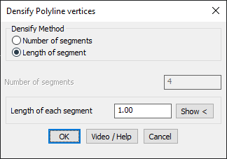
- Two Densification Methods:
- By Number of Segments – Divides each polyline segment into a specified number of equal parts.
- By Length of Segment – Inserts vertices at fixed intervals along the polyline.
- Enhances Polyline Precision – Useful for refining polylines for GIS applications, contour adjustments, and road alignments.
- Limitations:
- Does not work on polylines with arc segments. These must be pre-processed using other GeoTools commands before densification.
Benefits:
This tool is essential for surveyors, civil engineers, and CAD professionals requiring high-precision polyline modifications.