Summary
The GT_DANGLECHECK command in GeoTools identifies free-standing (dangling) endpoints of polylines, lines, arcs, and splines, ensuring accurate connectivity in BricsCAD, AutoCAD, ZWCAD and ARES Commander.
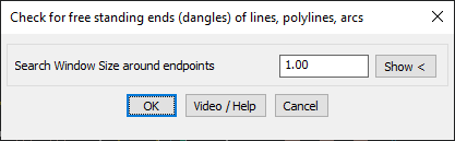
GeoTool -> Drawing Cleanup Tools -> Drawing Cleanup Tools -> Detect free ends (dangles) of lines,polylines and arcs
Key Features Include:
- Detects Dangling Ends:
- Scans drawing for endpoints of linework that do not connect to another object.
- Useful for identifying gaps and misaligned connections in networks.
- Customizable Search Window:
- Users define a search window size to specify the tolerance for detecting free-standing ends.
- Temporary Layer for Visualization:
- Marks all detected dangles using point objects in the GeoTools temporary layer (“GEOTOOLS_TEMP”), allowing easy review and correction.
Benefits:
This tool is crucial for GIS, surveying, road design, and utility mapping, helping ensure clean and well-connected linework.