Summary
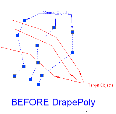
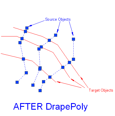
The GT_DRAPEPOLY command in GeoTools allows users to drape a 3D polyline (source objects) over a set of intersecting linear objects (target objects). This tool is essential for terrain modeling, roadway alignments, and surface analysis where elevation data needs to be aligned with existing linear features.
GeoTool -> Build Tools -> Build Tools -> Drape a 3D Polyline across a set of Intersecting Linear Objects
Drape a 3D Polyline Across a Set of Intersecting Linear Objects: GT_DrapePoly – GeoTools Command
Drape a 3D Polyline Across a Set of Intersecting Linear Objects: GT_DrapePoly – GeoTools Command
Key Features Include:
Drape Polylines Over Target Linear Objects:
- Automatically creates vertices along the source polyline at every point where it intersects the target objects.
- Uses 3D intersection values if the target objects contain elevation data.
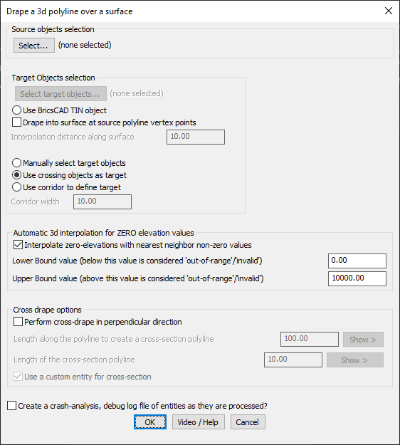
Selection Criteria:
- Source Objects: Accepts 3D polylines as input for draping.
- Target Objects: Supports lines, polylines (2D & 3D), arcs, splines, and 3D faces for intersection analysis.
Target Object Selection Methods:
- Manual Selection: Choose specific objects as targets.
- Crossing Selection: Automatically selects objects crossing the source polyline.
- Corridor-Based Selection: Define a width and select all objects within the corridor.
Automatic Elevation Interpolation for Zero Values:
- Allows interpolation of zero-elevation vertices using the nearest non-zero neighbor.
- Define lower and upper elevation bounds to filter out invalid elevation values.
Cross-Drape Options for Perpendicular Sections:
- Creates cross-section polylines perpendicular to the source polyline at regular intervals.
- Users can specify custom cross-section entities for enhanced visualization.
Benefits:
- Improves terrain accuracy by aligning polylines with real-world surface data.
- Essential for infrastructure planning, roadways, and contour adjustments in GIS and CAD.
- Automates the vertex generation process, reducing manual workload.
- Supports multiple CAD platforms like BricsCAD, AutoCAD, ZWCAD, and ARES Commander for flexible usage.
This tool is a must-have for surveyors, civil engineers, and GIS professionals dealing with 3D surface modeling and topographic data refinement.
Example: